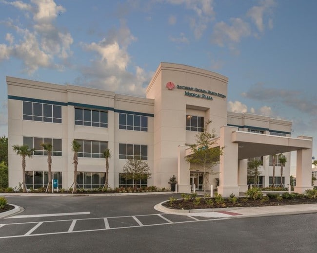
Property Record
2000 Dan Proctor Dr, Saint Marys, GA 31558
NEARBY LISTINGS FOR SALE OR LEASE
Property Detail
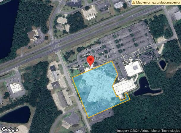
2000 Dan Proctor Dr
St. Marys, GA
HOSPITAL/LAND TRACT A
121-007H01
Camden
Charitableorganization
Georgia
0
5 AC
2025
Brunswick/Kingsland
010405
Other Market Areas
DEMOGRAPHICS near 2000 Dan Proctor Dr
1 Mile
3 Mile
5 Mile
2024 Total Population
1,949
24,245
40,764
2029 Population
2,189
26,620
44,681
Pop Growth 2024-2029
+ 12.31%
+ 9.80%
+ 9.61%
Average Age
34
36
36
2024 Total Households
755
9,183
14,760
HH Growth 2024-2029
+ 12.45%
+ 9.92%
+ 9.79%
Median Household Inc
$44,123
$72,382
$64,480
Avg Household Size
2.50
2.60
2.60
2024 Avg HH Vehicles
2.00
2.00
2.00
Median Home Value
$196,031
$237,708
$225,997
Median Year Built
1997
1999
1996
Nearby Places
Map Layers
Map Styles
 Street
 Aerial
- Restaurants
- Banks
- Shops
- Fitness
- Groceries
PUBLIC TRANSPORTATION
AIRPORT
Jacksonville International
DRIVE
WALK
Distance
Jacksonville International
37 min
28.3 mi
Freight Ports
Georgia Ports - Brunswick
DRIVE
WALK
Distance
Georgia Ports - Brunswick
42 min
32.5 mi
SALE & LEASE HISTORY
LISTING DATE
SALE/LEASE

Sep 25, 2016
For Lease
Nearby Properties
Address
Land Use
TOTAL SIZE
Lot Size
Zoning
Address
Land Use
TOTAL SIZE
Lot Size
Zoning
2,856 SF
51.84 AC
R-3
Address
Land Use
TOTAL SIZE
Lot Size
Zoning
1,456 SF
15.71 AC
R-3
Address
Land Use
TOTAL SIZE
Lot Size
Zoning
94,156 SF
74.30 AC
PD/R-1
Address
Land Use
TOTAL SIZE
Lot Size
Zoning
144,338 SF
35 AC
R-1
Address
Land Use
TOTAL SIZE
Lot Size
Zoning
26,410 SF
3.21 AC
C-3
Address
Land Use
TOTAL SIZE
Lot Size
Zoning
80,350 SF
28 AC
PD
Address
Land Use
TOTAL SIZE
Lot Size
Zoning
14,152 SF
14.25 AC
R-3
Address
Land Use
TOTAL SIZE
Lot Size
Zoning
79,447 SF
25 AC
PD/R-1
Address
Land Use
TOTAL SIZE
Lot Size
Zoning
80,714 SF
26.12 AC
R1
Address
Land Use
TOTAL SIZE
Lot Size
Zoning
64,504 SF
20 AC
C-ED
Address
Land Use
TOTAL SIZE
Lot Size
Zoning
64,810 SF
21 AC
R-1
Address
Land Use
TOTAL SIZE
Lot Size
Zoning
87,534 SF
25 AC
PD
Address
Land Use
TOTAL SIZE
Lot Size
Zoning
2,305 SF
20.92 AC
C-2
Address
Land Use
TOTAL SIZE
Lot Size
Zoning
123,108 SF
11.83 AC
R-3
Address
Land Use
TOTAL SIZE
Lot Size
Zoning
28,858 SF
5.09 AC
R-3
Address
Land Use
TOTAL SIZE
Lot Size
Zoning
8,544 SF
18.64 AC
C2
Address
Land Use
TOTAL SIZE
Lot Size
Zoning
139,255 SF
16.27 AC
I-L
Address
Land Use
TOTAL SIZE
Lot Size
Zoning
31,428 SF
5.80 AC
R-2
Address
Land Use
TOTAL SIZE
Lot Size
Zoning
16,598 SF
24.13 AC
PD/R-3
Address
Land Use
TOTAL SIZE
Lot Size
Zoning
95,196 SF
8.64 AC
C2
Address
Land Use
TOTAL SIZE
Lot Size
Zoning
2,833 SF
22.34 AC
PD/C2
Address
Land Use
TOTAL SIZE
Lot Size
Zoning
182,489 SF
22.88 AC
C-2
Address
Land Use
TOTAL SIZE
Lot Size
Zoning
15,590 SF
0.71 AC
C-4
Address
Land Use
TOTAL SIZE
Lot Size
Zoning
22,311 SF
6.39 AC
C-2
Address
Land Use
TOTAL SIZE
Lot Size
Zoning
3,000 SF
8.78 AC
C-2
Address
Land Use
TOTAL SIZE
Lot Size
Zoning
626.23 AC
P-D
Address
Land Use
TOTAL SIZE
Lot Size
Zoning
51,948 SF
2.08 AC
C-4
Address
Land Use
TOTAL SIZE
Lot Size
Zoning
55,497 SF
1.68 AC
C-4
Address
Land Use
TOTAL SIZE
Lot Size
Zoning
16,768 SF
8.96 AC
R-3
The World's #1 Commercial Real Estate Marketplace
Connect with us
© 2026 CoStar Group
The information above has been obtained from sources believed reliable. While we do not doubt its accuracy we have not verified it and make no guarantee, warranty or representation about it. It is your responsibility to independently confirm its accuracy and completeness. Any projections, opinions, assumptions, or estimates used are for example only and do not represent the current or future performance of the property. The value of this transaction to you depends on tax and other factors which should be evaluated by your tax, financial, and legal advisors. You and your advisors should conduct a careful, independent investigation of the property to determine to your satisfaction the suitability of the property for your needs.